|
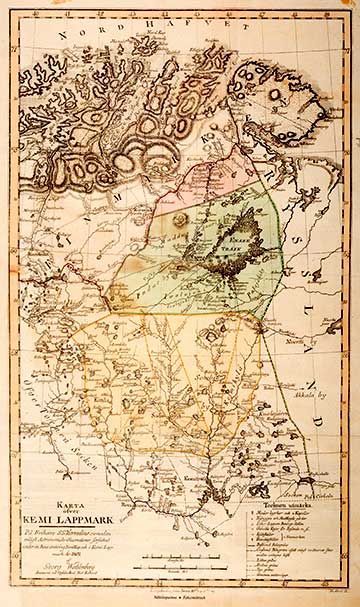
KARTA ÖFVER KEMI LAPPMARK 1804Georg Wahlenberg (1780-1851) was a Swedish natural scientist, geographer, doctor and professor of the University of Uppsala from 1828. He travelled mainly for the purpose of studying flora related matters, in Norrland in Norway and in Finland. The books Geografisk och ekonomisk beskrifning, om Kemi Lappmark (1804) and Berättelse, om... lappska fjällens höjd och temperatur vid 67 graders polhöjd (1808) were published based on these trips. However, Wahlenberg’s most important work was Flora Lapponica (1812) a considerably extended version of the work of his compatriot Carl von Linné having the same name (1737). The pioneering aspect of Wahlenberg’s book was the account of the distribution of vegetation zones included in the introduction of the book. Samuel Gustaf Hermelin (1744-1820) was a cartographer, baron and a mining counsellor who financed the surveying of the whole of Sweden, and above all the mapping of ore regions. The map publication (1797-1818) of Hermelin is the first comprehensive atlas of Sweden. Hermelin was granted permission to use the maps of the National Land survey of Sweden that were held secret until that time. He also had the exclusive right to publish maps from the country's regions for a period of 15 years. He was even allowed to employ the ships and tools of the kingdom for the performance of his tasks.
|