|
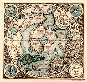
SEPTENTRIONALIUM TERRARUM DESCRIPTIO 1613It is a classic Arctic region map representing notions upheld in the late Middle Ages where the North Pole is depicted as a tall black mountain surrounded by four large islands. Three of the corners of the map have circled miniature maps of the Faeroe Islands, Shetland Islands and the mythical Frisland Island. In addition to being an eminent mathematician, Belgian born Gerhard Mercator (1512-1594) was the most renowned cartographer of the Renaissance. He changed his surname from Kremer to Mercator du Rupelmond. Mercator travelled extensively. He was also incarcerated for a short time suspected of his "false" opinions on religion and the universe. Mercator employed cartography principles according to the solar-based doctrines of Polish astrologer Nikolaus Copernicus (1473-1543). He established a cartography workshop in Duisburg in 1552. In 1569 he published a large and groundbreaking world atlas. He is renowned as the creator and developer of the map atlas. Mercator based his map drawing on precise measurements and the critical screening of findings. His name has established its place in history, especially in connection with seafaring. Navigation was once more based on the projection of Mercator. The map on the right presents an azimuthal projection by the North Pole, not Mercator's cylindrical projection, where the cylinder covers the globe from the Equator. In the field of geography, the divergence of Mercator from the Ptolemaic worldview (Klaudios Ptolemaios 100-178) has been said to be as revolutionary and significant as Copernicus's new philosophy in astronomy. Hondius (1563-1611), the Belgian artist, engraver and cartographer gained reputation especially from his early New World and European maps. In 1604 Hondius purchased the copper plates of Mercator's atlas from the heirs. The first edition of the Mercator-Hondius atlas was published in 1606. The son of Hondius, Henricus Hondius and son-in-law Joannes Janssonius continued the publication of the atlas. The map-publishing house of Hondius was one of the publishing houses that made Amsterdam the European centre of cartography in the seventeenth century.
|