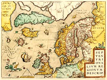
SEPTENTRIONALIUM REGIONUM DESCRIP 1570
This map depicting Northern Europe was published in the Ortelius Atlas Theatrum Orbis Terrarum. This picture is a facsimile of the map from 1967. The map includes an imaginary polar continent inhabited by pygmies. It also includes two of four islands believed to be located around the North Pole. Other imaginary islands are Grocland north of Greenland and Frisland in the Atlantic Ocean.
Abraham Ortelius (1527-1598) was a Dutch cartographer who primarily developed maps based on the principles of Mercator. These two gentlemen were the contemporaries of the era, and they were also friends. Mercator performed pioneering work as a natural scientist, whereas Ortelius was renowned for his skills at managing and combining large entireties. The first edition of Theatrum Orbis Terrarum was published in 1570.
For the first time in the history of the cartography Ortelius also included descriptive data in his maps. Numerous new, updated and extended editions of the atlas were published in 1570-1603. This map has been revered as a comprehensive presentation of sixteenth century information and skills in the field of cartography.
|