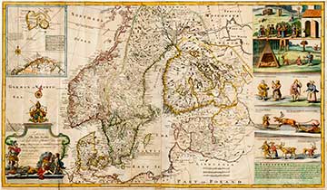
THIS NEW MAP OF DENMARK AND SWEDEN ACCORDING TO THE NEWEST AND MOST EXACT OBSERVATIONS 1715
The map of Dutchman Herman Moll (1654-1732) depicting the Nordic nations. The left top corner of the map has a small inserted map displaying Northern Norway, Lapland and Greenland. To the right of the map are five images with captions depicting the lives of the Sámi (Laplanders). The pictures were originally intended for the English language translation of the Lapponia work of Johannes Schefferus. However, due to space restrictions, they were excluded and ended up being used by Herman Moll.
|