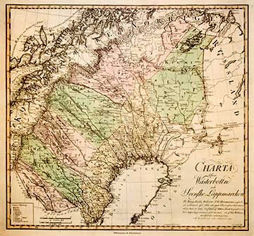
CHARTA ÖFVER WÄSTERBOTTN OCH SVENSKE LAPPMARCKEN 1797
The Inspector of Mines Anto Swab (1763-1809) and Mine Surveyor Clas Wallman (1774-1851) plotted the map of Västerbotten and Swedish Lapland that became the first map of the renowned atlas of Hermelin. This picture has been taken from the reduced facsimile from 1994.
Samuel Gustaf Hermelin (1744-1820) was a cartographer, baron and a mining counsellor who financed the surveying of the whole of Sweden, and above all the mapping of ore enriched regions. The map publication (1797-1818) of Hermelin is the first comprehensive atlas of Sweden.
Hermelin was granted permission to use the maps of the National Land survey of Sweden that were held secret until that time. He also had the exclusive right to publish maps from the country's regions for a period of 15 years. He was even allowed to employ the ships and tools of the kingdom for the performance of his tasks.
|