|
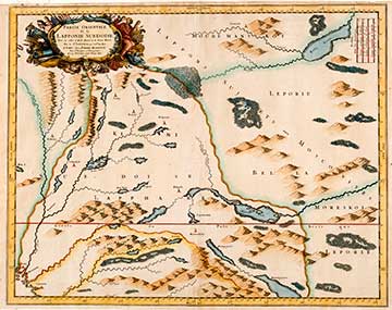
PARTIE ORIENTALE DE LA LAPPONIE SUEDOISE 1666Nicolas Sanson (1600-1667) served as the cartographer of the King of France during the period 1630 – 1665, and also acted as private tutor to Louis XIV. Sanson published a number of maps. His sons Guillaume (deceased 1703) and Adrian Sanson (deceased 1708) carried on their father’s business and work in the field of the cartography. Anders Bure (1571-1646), also known as Andreas Bureus or Bureaus, was the founder and developer of Swedish land surveying and cartography. Swedish issues of supremacy and frontier disputes with the neighbouring countries created the necessity for useful maps. Carl IX issued an order in 1603 for the commissioning of a map covering the whole of Scandinavia with Kustaa Adolf supporting the project rather generously. Bure's expansive Orbis Arctoi Nova Et Accurata Delineatio Auctore Andrea Bureo Sueco from 1626 long remained the model and basis for all maps representing the Nordic nations. Bure based his calculations on the doctrines and principles of Gerhard Mercator. His work Orbis Arctoi Imprimisque Regni Sueciae Descriptio, in English the Depiction of the Nordic Countries (1985), has been included as his introduction to the atlas illustrating knowledge on the area. Isaac Massa (1586 – 1643) was a Dutch shopkeeper renowned as a cartographer and specialist on Russia. His Russian experience also bestowed diplomatic tasks upon him even though he was self-educated and hardly learned to write during the course of his life.
|