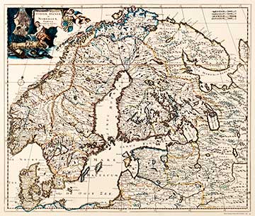
ACCURATISSIMA REGNORUM SUECIAE, DANIAE ET NORVEGIAE, TABULA 1700
This map published by Dutchman Justus Danckerts (1635-1701) represents the seventeenth century when Sweden was at its most powerful. In this map of Sweden, Denmark and Norway, the notion of superpower is clearly evident not only in the map’s cartouche, but also in the exaggerated borders of the kingdom. The decorative cartouche includes pictorial motifs representing Sweden's ore resources and forestry industry. This picture is taken from a facsimile of the map from 1967.
The atlases of Danckerts were discovered in Hungary in the library of the Faculty of the geography of the Josef Attila University in 1997. They are mentioned as being pleasing, clear and of a larger scale than many other maps of the time.
|